Leiden to Haarlem
Monday 28th June
 It
was an early start this morning in order to catch the morning opening of the railway
bridge at Sassenheim. The first four miles were following the marked channel across
the Kaag lakes, a popular sailing area dotted with polder islands. We arrived
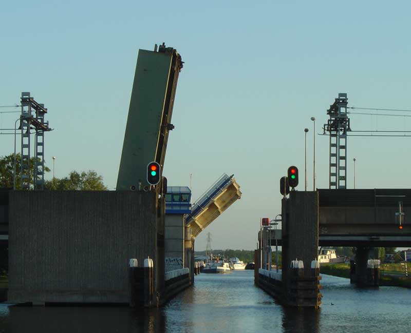
at the bridge in good time for the 6.28am lift and were pleased to see the lights
turn to red/green to acknowledge our presence. The bridge opens three times between
5.56am and 7.03am and again at lunchtime in the evening, with the exact times
being given in the Almanak (Part 2). From here we cruised past the famous bulb
fields south of Lisse, although at this time of year there was little to see.
By the time we reached the bridge it was time for the 7am start to the days service
times and we passed straight through. The next bridge, Elsbroekerbrug, was not
mentioned in our pilot, but given that it was published in 1988 (the latest edition
available) we accepted that a new road could have appeared in that time. There
is a real need for an up to date guide to the inland waterways of the Netherlands,
but it seems an area not favoured by publishers or their writers. The three remaining
bridges opened on approach allowing us to make our scheduled breakfast stop at
the Cruquius Museum.
It
was an early start this morning in order to catch the morning opening of the railway
bridge at Sassenheim. The first four miles were following the marked channel across
the Kaag lakes, a popular sailing area dotted with polder islands. We arrived
at the bridge in good time for the 6.28am lift and were pleased to see the lights
turn to red/green to acknowledge our presence. The bridge opens three times between
5.56am and 7.03am and again at lunchtime in the evening, with the exact times
being given in the Almanak (Part 2). From here we cruised past the famous bulb
fields south of Lisse, although at this time of year there was little to see.
By the time we reached the bridge it was time for the 7am start to the days service
times and we passed straight through. The next bridge, Elsbroekerbrug, was not
mentioned in our pilot, but given that it was published in 1988 (the latest edition
available) we accepted that a new road could have appeared in that time. There
is a real need for an up to date guide to the inland waterways of the Netherlands,
but it seems an area not favoured by publishers or their writers. The three remaining
bridges opened on approach allowing us to make our scheduled breakfast stop at
the Cruquius Museum.
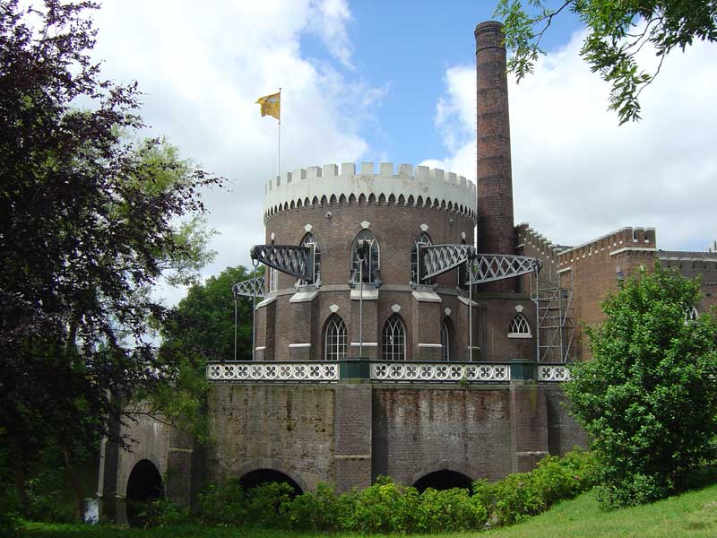 One of three pumping stations
completed in 1849 to drain the Haarlemmermeerpolder, the English steam engine
which powered Cruquius could do the work of 160 windmills. The neogothic architecture
has long been replaced by more discreet, modern equipment but the building remains
to recall its history. The boilers have been cleared out to make space for an
informative museum, but the original steam engine can still be seen in operation,
now driven by electricity. The museum's landing stage is really designed to accommodate
the owner's boat but provided us with a convenient berth whilst we visited the
museum and its adjoining tea house. .
One of three pumping stations
completed in 1849 to drain the Haarlemmermeerpolder, the English steam engine
which powered Cruquius could do the work of 160 windmills. The neogothic architecture
has long been replaced by more discreet, modern equipment but the building remains
to recall its history. The boilers have been cleared out to make space for an
informative museum, but the original steam engine can still be seen in operation,
now driven by electricity. The museum's landing stage is really designed to accommodate
the owner's boat but provided us with a convenient berth whilst we visited the
museum and its adjoining tea house. .
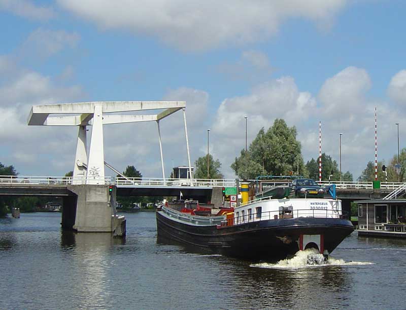 From
the Cruquiusbrug it is only a mile to the first of eight bridges through the centre
of Haarlem, operated as a convoy system. Here we were caught up by a barge in
a hurry, and were able to follow him all the way through the city. Quayside moorings
are available between the bridges, some with electricity or water. However, all
looked rather full, noisy or insecure and so, after a stop at the Harbour office
to settle our dues, we opted to continue on to the peaceful surroundings of the
Haarlemsche Jacht Club to the north of the city.
From
the Cruquiusbrug it is only a mile to the first of eight bridges through the centre
of Haarlem, operated as a convoy system. Here we were caught up by a barge in
a hurry, and were able to follow him all the way through the city. Quayside moorings
are available between the bridges, some with electricity or water. However, all
looked rather full, noisy or insecure and so, after a stop at the Harbour office
to settle our dues, we opted to continue on to the peaceful surroundings of the
Haarlemsche Jacht Club to the north of the city.
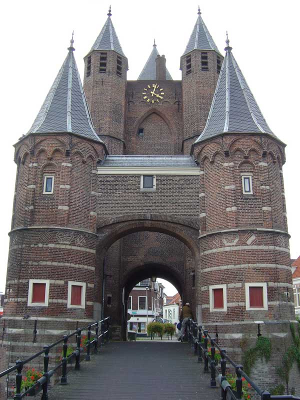 From
the yacht club it is a 15 minute cycle ride into the city along the River Spaarne.
The heart of the old city is the market square overlooked by Sint Bavo's Grote
Kerk, completed in 1550 after 150 years of construction. Teyler's Museum on the
Spaarne waterfront has the distinction of being the first major museum to be founded
in the Netherlands established in 1778 to encourage the study of science and art.
We opted instead for the more low key Historisch Museum housed in a former almshouse.
This depicts the history of the city, including an entertaining video enlived
by 3D visual aids.
From
the yacht club it is a 15 minute cycle ride into the city along the River Spaarne.
The heart of the old city is the market square overlooked by Sint Bavo's Grote
Kerk, completed in 1550 after 150 years of construction. Teyler's Museum on the
Spaarne waterfront has the distinction of being the first major museum to be founded
in the Netherlands established in 1778 to encourage the study of science and art.
We opted instead for the more low key Historisch Museum housed in a former almshouse.
This depicts the history of the city, including an entertaining video enlived
by 3D visual aids.
Cruising Statistics
Distance: 17 nm
Total to date: 1036 nm
Avg Speed: 5 knots
Duration: 3:30 hours
Diesel: 46 litres
Wind: WSW-SW 3/4
Mooring:
€12
Electricity: Included
Bridges
Sassenheim rail (lift)
Sassenheim road (lift)
Lisse (lift)
Elsbroekerbrug (lift)
Hillegommerbrug (lift)
Bennebroekerbrug (lift)
Cruquiusbrug (lift)
Schouwbroekerbrug (lift)
Buitenrustbrug (lift)
Langebrug (lift)
Melkbrug (lift)
Gravestenenbrug (lift)
Catharijnebrug (lift)
Haarlem rail (lift)
Prinsenbrug (lift)
Waarderbrug (lift)
Charts
ANWB Waterkaart H