Yerseke to Goes
Tuesday 19th August
 We
had arranged to meet MBM friends in Goes when they arrived there on Wednesday
and opted to make the short passage today in order to secure a berth.
It was nearing low water again by the time we left Yerseke, but this time
we missed the sharp turn to port as you exit the marina and were half
way on to a sandbank before we realised we were going the wrong way. Luckily
Virginia Lady were on hand to give us a tug and we were soon on our way
with only our pride taking a dent.
We
had arranged to meet MBM friends in Goes when they arrived there on Wednesday
and opted to make the short passage today in order to secure a berth.
It was nearing low water again by the time we left Yerseke, but this time
we missed the sharp turn to port as you exit the marina and were half
way on to a sandbank before we realised we were going the wrong way. Luckily
Virginia Lady were on hand to give us a tug and we were soon on our way
with only our pride taking a dent.
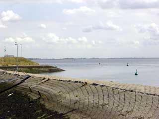
 It
was a fine day for the short trip and we could see bathers enjoying the
sandy beach at Wemeldinge, close to the harbour entrance. North of Kattendijke
the green buoys to port change to red ones, marking the entrance channel
to the lock at Sas van Goes. As we approached, the lock gates opened and
with only a few yachts waiting we could go straight in and lock through
into the Havenkanaal to Goes.
It
was a fine day for the short trip and we could see bathers enjoying the
sandy beach at Wemeldinge, close to the harbour entrance. North of Kattendijke
the green buoys to port change to red ones, marking the entrance channel
to the lock at Sas van Goes. As we approached, the lock gates opened and
with only a few yachts waiting we could go straight in and lock through
into the Havenkanaal to Goes.
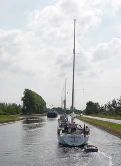
 The
transit went smoothly with all the bridges opening shortly after our arrival
and we were welcomed by the harbour master as he operated the Ringbrug.
At the entrance to the De Werf marina there was a slight hold up as two
yachts got their masts entwined, causing gridlock in the narrow entrance.
Fortunately there was room to skirt round them and continue on into the
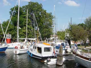
Stadshaven. There was another flotilla already rafted in the head of the
basin, taking over most of the quayside for their pontoon party. We found
an alongside berth against the narrow landing stage near the St Maartens
brug, although the access to the shore was via a plank and a ladder.
The
transit went smoothly with all the bridges opening shortly after our arrival
and we were welcomed by the harbour master as he operated the Ringbrug.
At the entrance to the De Werf marina there was a slight hold up as two
yachts got their masts entwined, causing gridlock in the narrow entrance.
Fortunately there was room to skirt round them and continue on into the
Stadshaven. There was another flotilla already rafted in the head of the
basin, taking over most of the quayside for their pontoon party. We found
an alongside berth against the narrow landing stage near the St Maartens
brug, although the access to the shore was via a plank and a ladder.
Cruising Statistics
Distance: 9 nm
Total to date: 2073 nm
Avg Speed: 4 knots
Duration: 2 hours
Diesel: 20 litres (est)
Mooring:
€13/night
Electricity: €0,50 meter
Tourist tax: €0,72pp/night
Locks
Sas van Goes
Bridges
Wilhelminabrug
Ringbrug
St Maartens
brug
Waypoints
Yerseke
harbour
51 29.92N 04 03.54E
Yerseke
channel
51 30.90N 04 02.57E
Sas van
Goes
51 32.33N 03 56.23E
Charts
1805.9
1805.5