Lezardrieux to Paimpol
Tuesday 17th June
 Our
destination for today was the fishing port of Paimpol, with its drying
approaches across the Anse de Paimpol. An early high water meant a 0730
start - not too popular with our new crew members. Although only a short
passage, the narrow channel between the Ile de Brehat and the mainland
gave us plenty to think about.
 The
weather was forecast to be up to a force 6, normally too lively for us,
but as we would be keeping within the estuary and sheltered by the island,
we considered it safe to venture out.
 We
had plotted a course through the rocks of Le Ferlas passage in the Rade
de Brehat, south and west of the island, and in the fast flowing cross
tides, we were glad to be sheltered from the worst of the fresh northwesterly
breeze. As we turned south we picked our way though more rocky outcrops
through the Chenal de Denone and were pleased to see other vessels moving
about in the entrance to harbour.
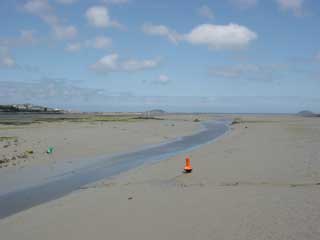
Unfortunately most of these were fishing boats and we came upon a maze of fishing markers lurking among the waves in the approach to the port, just pulling back the throttles in time to drift over them in neutral. Buoys mark the final approach channel, which at low tide becomes a trickle, surrounding by acres of mud and stranded markers.
As we arrived we were directed to a finger berth on pontoon A, and settled down to a late breakfast and a chance to explore.
Cruising Statistics
Distance: 12 nm
Total to date: 1114 nm
Avg Speed: 6 knots
Duration: 2 hours
Diesel: 50 litres (est)
Wind: WNW 4-5
Mooring: €20/night
Electricity:Free
Waypoints
(European
datum)
Lezardrieux
Marina
48 47.44N 03 05.80W
Pointe de Coatmer
48 48.36N 03 05.43W
Olenoyere PHM
48 48.76N 03 05.13W
Roch Levret
PHM
48 49.53N 03 04.21W
Rampa IDM
48 49.58N 03 02.71W
La Chambre SCM
48 50.07N 02 59.21W
Ar Bonn Krenv ECM
48 49.27N 02 57.42W
La Jument PHM
48
47.55N 02 58.19W
El Bras
SH Beacon
48 47.26N 03 01.28W
Paimpol Jetee de Kernoa 48 47.18N 03 02.34W
Charts
AC 3673
